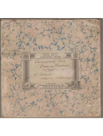


GWENDRAETH FACH FISHING PRESERVE. J. Thomas, Velindre, Kidwelly.
# ND (c.1910). A custom-made linen-backed folding map. (407 x 920mm - 155 x 152mm folded). b/w map with the 11 beats belonging to Thomas and his neighbours marked in different colours. Hand-written title on an Edward Stanford label, typed (or duplicated) schedule listing the waters.
# A custom-made cloth-backed map (5" to 1 mile), showing the preserves owned by John Thomas Esq., Velindre, Kidwelly. b/w map with the 11 beats belonging to Thomas and his neighbours marked in different colours. The River Gwendraeth Fach is in Carmarthenshire, South Wales. The cartographic company, Edward Stanford of London, were agents for the Ordnance Survey. It is evident that they could produce and sell maps for a particular area, on request.
# A custom-made cloth-backed map (5" to 1 mile), showing the preserves owned by John Thomas Esq., Velindre, Kidwelly. b/w map with the 11 beats belonging to Thomas and his neighbours marked in different colours. The River Gwendraeth Fach is in Carmarthenshire, South Wales. The cartographic company, Edward Stanford of London, were agents for the Ordnance Survey. It is evident that they could produce and sell maps for a particular area, on request.
£120.00
Availability:
In stock
Book Code
57673
| Author | Stanford (Edward). |
|---|---|
| Book Code | 57673 |
| ISBN | No ISBN. |
| Book Description | Slight use but very good. Marked in pencil as 5" to 1 mile, but actually the Ordnance Survey 6" to 1 mile map. Not dated but from the early years of the twentieth century. |
| Book Cover | Map |
| Published Date | 1910 |
| Publisher | Edward Stanford Ltd. |
| Place | London. |